
Walking the South Downs Way. Summer 2021
- Anne B 10milesfrom

- Sep 27, 2021
- 11 min read
Our latest Adventure! If you enjoy it, do give it a 'Like', and even better, sign up to receive an email when new blogs are published!

After walking the Hadrian's Wall path in June, we wanted a new challenge.
The South Downs Way is a glorious long distance trail running 100 miles from Winchester in Hampshire to Eastbourne in East Sussex. It follows the ridges of the chalk hills, laid down millions of years ago when this area was under a shallow sea. Mainly suited to walkers, cyclists and horseriders.
I walked it in 1975 when the western part was not included, and I was very much younger!
This time Chris and I were walking with our friend Alan, and organising the walk into 12 separate chunks throughout the summer. Most days were between 7 and 11 miles as we are all in our 60s and creaking a little more than when I did it 46 years ago. We did the first 3 parts as day trips from home. It is a super walk with great views, interesting history and many nature reserves with rare plants and butterflies, but not always an ideal route for using public transport to get back to the start each day. Our budget did not allow the use of taxis, or B&B’s, so we were camping. Chris and I in Buzzbee, our campervan, and Alan, bravely, in a tent. Using Alan’s car as well gave us 2 vehicles, which gave us freedom about where to start and finish each day, although we had to be mindful of car parks with height barriers for the campervan. Thankfully there aren’t many.

The walk starts at the National Trust Mill in Winchester, and King Alfred waved us on our way on a sunny Tuesday in July, as we started the first leg of the 100 mile South Downs Way, aiming to end at Milburys pub. Leaving Winchester, we could have called at the porter’s lodge of the Abbey of St Cross, and been given a small glass of Ale and piece of bread. Known as the Wayfarer’s Dole, it is the oldest charity in England. It seemed a bit early, so we walked on, past the last remaining, tiny section of the city's roman walls, out of the city and across the M3.


The walk was undulating, and a gentle easing in to the route. Summer was all around us with wildflowers and fields of ripening wheat. The area behind Cheesefoot head is Mapperton Bowl where over 100,000 US troops were addressed by Eisenhower just prior to their D Day embarkation, conjuring up a very different picture and atmosphere to the peace we witnessed. Lots of red kites were in evidence too. Paths good, even after recent rain. Just a few muddy spots in shady hollows. Reaching the Milburys pub at the end of day 1, it was closed, so our celebratory pint was at the delightful Ship Inn at Owlesbury.


A few weeks later, we accomplished Day 2. 7 miles from Milburys to Old Winchester Hill. Stunning views, flowers and butterflies all the way, and a few steeper hills. A taste of what is to come.


Chalk deposits are usually associated with layers or cappings of flint, which were used extensively in walls and buildings. The pretty village of Exton with its lovely 13th century church was a highlight, and we returned there later for a celebratory pint at the riverside Shoe Inn.


The day ended with a climb up Old Winchester Hill, with panoramic views and the site of a 4000 year old Bronze age settlement, although there is evidence of occupation dating back 8,000 years. Burial mounds are still in evidence. A super picnic with a view, and a stunning green visitor!
The storm clouds gathered around, but never reached us. What a fabulous day's walking. If you have any spare time, Hinton Ampner National Trust house is worth a visit!
Day 3 of our South Downs Way walk started with a descent into the Meon Valley and then a mix of woodland and farmland, again with beautiful wild flowers in evidence, making the bees happy!


Then, we bagged a Marilyn! Sounds a bit dodgy, but it means we reached the top of a hill designated as a Marilyn... over 150 metres higher than any land around it. Here we are at the trig point on Butser Hill. A Marilyn, but also the highest point on the walk at 271 metres (899 feet), and site of another iron age fort. 7.5 miles walked today to Queen Elizabeth Country Park.

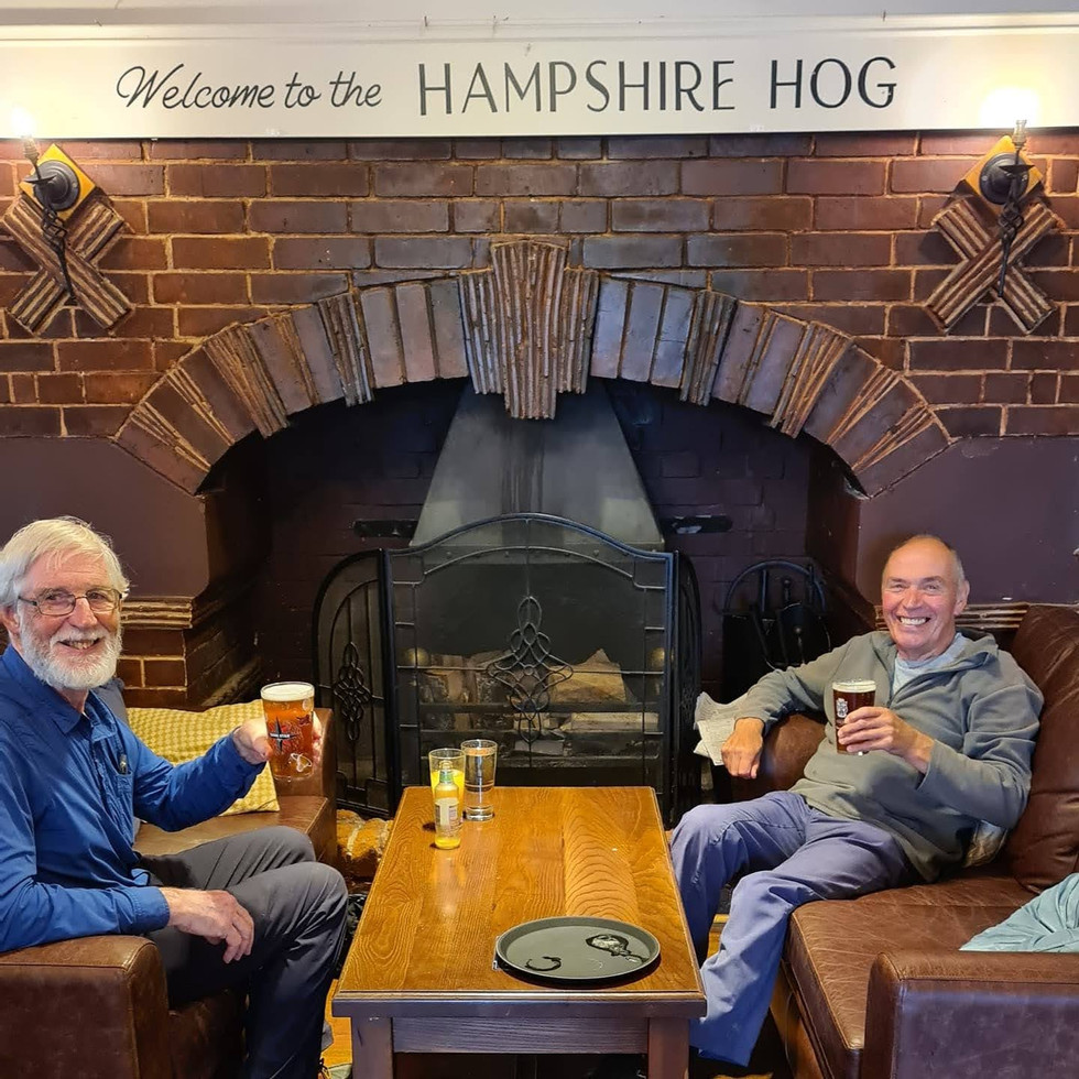
Late summer flowers, lovely flint and brick architecture, gorgeous woodland and of course great views across to the Isle of Wight. Today's celebratory pint was at the Hampshire Hog pub! Oh... and we might have had celebratory ice creams too!!


Into August, and now we are camping for 3 days in Buzzbee our campervan, resuming our South Downs Way walk, and staying at Old Farm campsite in Slindon. (Alan is in his tent!)
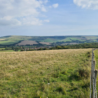
Day 4 of the trail took us from Queen Elizabeth Country Park to Cocking Hill Car Park. It was overcast but that didn't spoil the views, and prevented it from being too hot. To get views like this you need to climb hills and there were a lot. Harting Down and Beacon Hill were stunning.


Look for Alan in picture 3 for an idea of scale! Along the top of the downs are the Devil's Jumps, five long bell barrows, over 3000 years old, and aligned with the setting sun on midsummers day.


We also found this rather poignant small memorial just to one side of the South Downs Way near Didling – dedicated to a 25 year-old German Pilot called Hauptmann Joseph Oestermann who was shot down and killed over The South Downs on the 13th August 1940.
Apparently Oestermann was flying a Ju88 bomber on the first day of Germany’s offensive against the RAF. The bomber was downed by Pilot Officer Mayers of 601 Squadron flying a Hurricane out of nearby Tangmere Airfield just a few miles east of Chichester.
Two other airmen from the German plane parachuted to safety and were captured. It was moving to see the memorial with recent poppy wreaths.
We are quite chuffed to have done 10.1 hilly miles today, and rewarded ourselves with an excellent pub meal and a pint at the very friendly Spur Inn on the A29 near Slindon. Another 10 miler tomorrow, gulp!

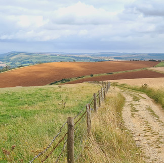
More amazing views on Day 5 of our South Downs Way walk from Cocking Hill Car Park to Whiteways near Arundel. 10.8 miles today with cloudy skies, but again, it would be much too hot if the sun was shining! Splitting the walk up means we have been watching the seasons progress.


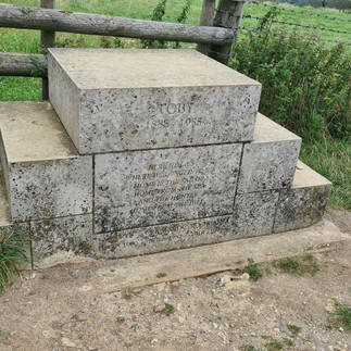
Lots of signs of late summer. Beautiful fields of swaying wheat, lots of wildflowers, and the harvest being gathered in earnest. We stopped for our picnic at Toby's stone, a mounting block in memory of a local huntsman who loved the view. We could see why, and didn't think he would mind us sitting on it! Close to the roman road of Stane street, the signs took on a strangely Roman feel!


An excellent new cafe at Littleton Farm Upwaltham, was a great stop for lovely tea and cake. We recommend it!


Worth a visit if you have time are Bignor Roman Villa with its excellently preserved mosaics, and beautiful West Dean Gardens. Who knew that nearly 2000 years ago, mosaic creators were signing their work with initials or trademarks?!

Day 6... "Can we go in for a pint?"
"Certainly not! It's only 9.15 in the morning!". Today's South Downs Way walk took us from Whiteways down to Amberley and up and over to Washington! 7.8 miles of glorious walking which included the River Adur, wildflowers, gliders overhead launched below us at Parham airfield, a Spitfire doing barrel rolls, and great views all around.


Lots of friendly people to chat to, all loving the trail. Two places to visit around here would be the Amberley Chalk pits museum, and Parham House. We headed home after our 3 days walking, and will return in a few weeks for the next 3 days!
Day 7 was 7 miles from Washington to Upper Beeding. Great scenery, still lots of wildflowers around although the harvest is in and it feels a little more autumnal.


Chanctonbury Ring bronze age hill fort has stunning views, and remnants of a 6000 year old flint mine! The ring is also a ring of beech trees planted in 1760, and although many were destroyed in the 1987 hurricane, they have been replanted.


Steyning bowl is a beautiful downland valley, and St Botolphs church has a chancel arch over 1000 years old with traces of ancient paintings, and a rare Jacobean pulpit.
A free range pig farm with piglets made my day! This really is a wonderful walk. Then a drive to our camping base at the lovely Southdown Way campsite near Hassocks, which is run by the Lantern Trust and all profits go to their charity providing therapy and facilities for people with visual impairments and other disabilities. Of course we had to stop on the way for a celebratory pint at the quaint Jack and Jill Inn. More on Jack and Jill tomorrow!


Day 8 was quite a day! 10.5 miles and some big climbs, starting with Truleigh Hill, and it's Youth Hostel which was newly opened when I stayed in it on my first South Downs way walk in 1975! A map of the whole walk, showing the ascents and descents was on the wall. Alan said he would never have agreed to come if he had seen that first!

The day also included climbing up to Devil's Dyke and Ditchling Beacon, but the rewards were some gorgeous views and some curiosities. In Victorian times there was a funfair, cable car and funicular at the top of Devil's Dyke! Today the National Trust secondhand bookshop at Devils Dyke yielded several super books for our grandchildren…and then I realised I had to carry them for the rest of the day! The pub was closed, but brought back more memories of my friend Caroline and I in 1975 drinking lager and lime here after our climb. And yes… we were a little under age!


Pyecombe church was built in the 12th century. The Church gate is a local design called a Tapsell gate, which keeps animals out but allows coffins in! This font dates from 1170 and is one piece of lead bent into a drum shape. In the Civil war it was painted with whitewash so it looked like stone to prevent the soldiers taking it to make bullets! This welcoming church also had a serve yourself tea and coffee spot!


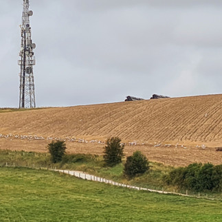
The Jack and Jill windmills are just off the route. Jill is restored and working. It was the 1st of September,and we saw this lovely autumn scene with flocks of gulls following a plough at Truleigh Hill. Cool and cloudy which affects the photo quality, but better than hot sun for walking!


Today was also the day of maps, all showing some or all of the route in different ways, including National Trust involvement, and this lovely map done in tiles on the loo wall at Saddlescombe farm, where there is a welcome cafe. Another 10 miler tomorrow. Zzzzzz
Day 9 South Downs Way walk 10.4 miles and some of the best views yet. Ditchling Beacon to Rodmell. Autumnal harvest scenes but still so many wildflowers. Tiny Speedwell and Scarlet Pimpernel were pushing up through the stubble.


You may wonder what Chris and Alan are doing here, but they are just standing astride the Greenwich Meridian 0 degrees, which crosses the path at this point! Our picnic spot gave us great views down to Lewes, but a strong wind meant an innovative idea was needed to keep the beer glasses upright!


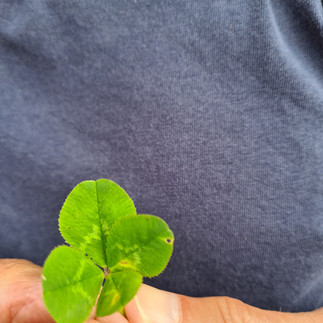
Alan also found a 4 leaf clover, and both of them were excited to see the signpost to a pub!
80 miles of the 100 are now walked, so we had celebratory icecream in Buzzbee the campervan.


Hopefully we will return in a few weeks to finish this wonderful walk, before the weather gets too cold for Alan in his tent! (He does have an electric blanket!)
Day 10 saw us back in Sussex on the first day of Autumn, and walking from Rodmell to Alfriston. Lovely start at this great 1880's swing Bridge over the River Ouse. Signs of Autumn were everywhere, and superb views as we have come to expect on this amazing long distance trail.


Coffee break at Firle Beacon and lunch at Bopeep viewpoint, both obligingly offering benches, which was helpful as the Autumn dew was very much in evidence. Hang glider pilots were waiting hopefully for a breeze to allow them to launch, but it was an incredibly still day. Far below the ridge was Firle Place, home of the Gage family, who famously brought a European green plum into England in 1724, and called it a Greengage. The next village was Charleston, home of the farmhouse frequented by authors and artists of the very bohemian Bloomsbury set like Virginia Woolf, Vanessa Bell and Duncan Grant. Today it hosts workshops and an art gallery. Our walk ended in picturesque Alfriston with lovely tea and cake at Badgers tea room! So good I forgot to take a photo.


The very first property ever acquired by the National Trust is the Alfriston Clergy house, bought in 1896 for £10! Dirk Bogarde stayed in his family’s cottage above the village many times when he was a boy, and his first autobiography, Great Meadow creates a wonderful image of life here in the 1920’s, and somethings hardly seem to have changed!
Back to the excellent Homestead campsite CCC certificated site at Hailsham, our base for these last 3 days.


Day 11 saw us walking 8 miles from Alfriston to Birling Gap. Lovely Alfriston church, known as the Cathedral of the Downs, gazing dreamily out over the Cuckmere valley for 900 years. Sleepy Westdean village, 1000 years old and, incredibly once home to King Alfred's palace, and a naval command base! The parsonage was built in 1280, and is apparently the oldest continuously occupied house in England. The white horse at High and Over is clearly seen from this side of the valley, and gradually the marvellous meanders of the Cuckmere river come into view. We walk down the river estuary, with Seaford Head across the other side.


Now to start climbing the first of the beautiful (and hilly) Seven sisters white cliffs, on a lovely sunny day! We climbed and descended 6 sisters before reaching our car at Birling Gap, and we were pleased to have an ice cream, followed by a celebratory drink at the very quaint Tiger Inn at East Dean. This was the last night of the walk, and so we treated ourselves to a super meal at the Plough at Upper Dicker. Topped off by a super Harvest Moon. What a day! Just 4 miles tomorrow to finish our 100 mile walk!


Day 12. Up early to take the tent down, and then just 4 hilly miles to walk from Birling Gap. Not sure why, but I really liked their quirky bike racks! Up past Belle Tout Lighthouse, once again precariously close to the cliff edge, and over the 7th sister, and then on to magnificent but notorious Beachy Head.


Great views again all day, but also a few more sobering sights. Firstly the massive cracks in some of the cliffs which will soon end in rockfalls and further loss of these iconic landmarks, including the now precariously place Belle Tout lighthouse. Secondly, a young man standing worryingly near the edge at Beachy Head. He was spotted by the ever present observer teams, spoken to, and he went away with them. It could have been a different outcome. Many people come close to that desperation, so we will be making a donation to the MIND charity in grateful thanks that we were able to appreciate the joy of this amazing walk. Several memorials include one to PC Harry Ward, a forerunner of today's teams, who patrolled on his horse. The path also goes past a poignant memorial to Bomber command, many of whom would have flown over Beachy Head en route to their targets. For many, it would have been their last ever view of England.


We then descended into Eastbourne to the marker saying we had completed our 100 mile walk along the South Downs Way from Winchester.


We ended with certificates, available from the National Trails website, and proceeds go to maintaining the trails. They do a great job, as the signposting has been really excellent on the whole length of this walk, and there were drinking water taps provided at intervals too.
We were amazed at the remoteness of many parts of the trail, despite us being in the most populated corner of the UK, and there were a few occasions where you could walk 8 - 10 miles without any toilets or refreshment options, so come prepared! The views everyday were breathtaking. It is certainly one of our favourite long distance paths.
We think you could do this any time of year, but it could be very muddy and slippy after rain, and the downland scenery means there is little shelter on many of the ridges.
Our whole trip ended with fish and chips on Seaford seafront in Buzzbee!
Now... where to next!


Comments